Filter: Categories of Wisconsin Historical Images
Filter: Subject of Madeline Island (Wis.)
Filter: Categories of Wisconsin Historical Images
Filter: Subject of Madeline Island (Wis.)
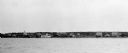
| Date: | 02 1948 |
|---|---|
| Description: | Elevated view of the enclosed wind sled shaped like the Maybe, sitting on the ice with La Pointe dock on the left. |
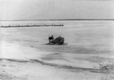
| Date: | 1920 |
|---|---|
| Description: | Howard Russell with dog team bringing the mail to La Pointe. |
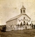
| Date: | 1910 |
|---|---|
| Description: | People gathered around picket fence in front of a decorated St. Joseph's Catholic Church in La Pointe on Madeline Island. |
| Date: | 1916 |
|---|---|
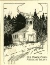
| Description: | Illustration of the Old Mission Congregational Church. The church was built in 1832 for a mission founded by Frederick Ayer in 1830. It is said to be the o... |
| Date: | 1918 |
|---|---|
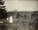
| Description: | Burial grounds in La Pointe. A man is standing in the center with his back turned to the camera. |

| Date: | 1905 |
|---|---|
| Description: | Indian cemetery. A large body of water is in the background. Caption reads: "Indian Burying Grounds, Bayfield, Wis." |

| Date: | |
|---|---|
| Description: | The Old Mission Inn, originally built as a mission house in 1832 by the Congregational mission established by Frederick Ayer in 1830. In later years furthe... |
| Date: | 1910 |
|---|---|
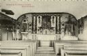
| Description: | The interior of St. Joseph's Catholic Church. It was built in 1841 by Father Frederick Baraga (later Bishop), who established his mission in 1835. A small ... |

| Date: | 1915 |
|---|---|
| Description: | Elizabeth Hull & Elizabeth Nesbit, sit outside on a bench on Madeline Island. |

| Date: | 1930 |
|---|---|
| Description: | Large group of fishermen standing on ice with catch of fish displayed on airplane wing near La Pointe, Madeline Island. |

| Date: | 1880 |
|---|---|
| Description: | This copy of an 1834 map in the American Fur Company's papers held by the New-York Historical Society shows an outline of Chequamegon Bay and Madeline Isla... |

| Date: | 1959 |
|---|---|
| Description: | This map shows landownership, acreages, and old fort road on the southwest corner of Madeline Island. The map includes an explanation of survey in the midd... |

| Date: | 08 1971 |
|---|---|
| Description: | Aerial view of Madeline Island, and a few of the Apostle Islands in the distance. |
If you didn't find the material you searched for, our Library Reference Staff can help.
Call our reference desk at 608-264-6535 or email us at: